Maps & Travelogues

Number of items: 167

Filter items

בחר קטגוריות להצגה
Select a category
Sold
Auction 092
Item 6
GEOGRAPHIAE SACRAE PARS PRIOR PHALEG, Samuel Bochart. France, 1646. First edition.

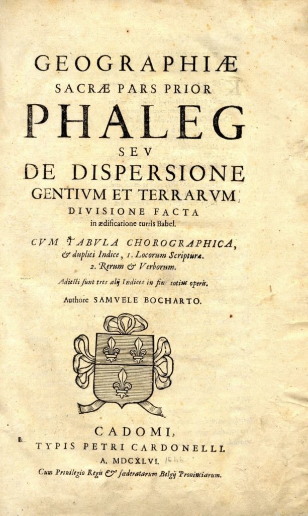
Bocharto Samuele was a prominent mapmakers and author of Holy Land travelogues. His geographic work has two sections and added maps. Many editions of the book were printed in Germany and Holland. But the first edition was printed in Cadomi, France today known as Caen. French. This edition is exceptionally rare. The book is divided into two sections. Geographiae Sacrae Pars Prior Phaleg and …Altera Chanaan. Both were printed in France in the above city in 1646. Together, both parts contain about 868 pages in addition to indexes and introductions: General: Map of Canaan-Eretz Israel and all of its surrounding areas, two miniature inset maps on the left side. A second map: Asia Major and inside many miniature maps both on the right and the left. A third map: Map of Italy and to its side, a map of Africa in a separate border.A fourth map: “Gizerat Segulia” (in Hebrew). All of the maps have listings of their places in Hebrew and Latin. This Hebrew map was printed some 50 years before the Hebrew Amsterdam map that is considered to be the first Hebrew map ever. Laor did not see these maps and referred to them in nos. 114 and 115 from a later Dutch edition. Weintraub in his book about “Hebrew maps” cites only one of the maps from this first edition, with an erroneous date of print (no. 22 in his book). As such, he apparently did not see the book itself. All of the maps are printed on large double size paper (41 x 34 cm.) and their condition as well as that of the book is very good.

Error: the field format must contains "%s" or "%1$s".

The price includes a buyer's commission

Auction 092
Item 7
Colored Map of Palestine. Tel Aviv, c. 1940

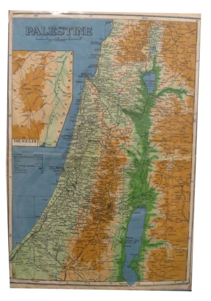
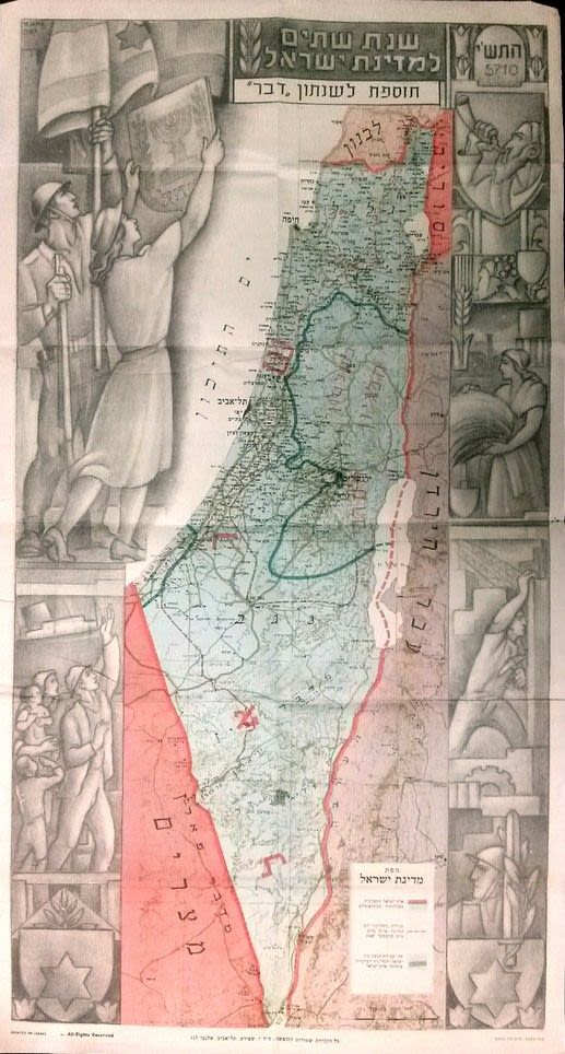
48×33 cm. Colored map including the Jewish and Arabic settlements at the end of the 1930s, including transportation routes, railroad tracks and a close up photo of the Negev. Pasted onto cardboard, light tear in the fold, fine condition.

Error: the field format must contains "%s" or "%1$s".
Auction 092
Item 8
Collection of Antiquated Maps of the Holy Land [8], 17th-18th Century.

Collection of eight geographic maps of the Holy Land. Various maps. Printed in various countries. Some maps with tribal divisions. Fine – very fine condition.

Error: the field format must contains "%s" or "%1$s".

The price includes a buyer's commission

Auction 092
Item 9
Collection of Antiquated Maps of the Holy Land [7], 17th-19th Century, Tribal Divisions.

Collection of seven antiquated maps of the Holy Land with tribal divisions. Printed in different countries. Fine-very fine condition.

Error: the field format must contains "%s" or "%1$s".
Auction 092
Item 10
Map of the Holy Land. 1858. 8 Sections.

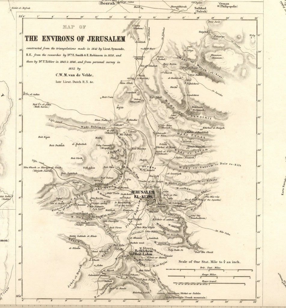
Map of the Holy Land by C.W.M. Welde. Printed in 1858, Gotha. Map comprised of 8 sections, together representing the entire Holy Land. Each section measures about 47×39 cm. Missing section 8, a square of Jerusalem, that doesn’t compromise the completion of the map. fine-very fine condition. Laor 778.

Error: the field format must contains "%s" or "%1$s".

The price includes a buyer's commission

Auction 089
Item 33
Portfolio of Israeli Maps [26]. Tel Aviv, [1967-1970]

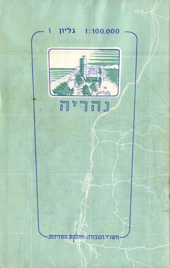
Portfolio including 26 Israeli maps. Ministry of Labor, Department of Measurements. Tel Aviv, [1967-1970]. 26 maps, each map measures 46×55 cm. Colored and folded as a booklet, within a case. The maps are on a scale of 1:100,000. Rare set of maps that are not in the National Library. Original, rubbed cardboard portfolio. Along the width of the portfolio there is a sketch of Israel and the division of the maps. The maps are in very fine condition.

Error: the field format must contains "%s" or "%1$s".
Auction 089
Item 34
Map of Israel. SABASTIAN MUNSTAR. Basle, C. 1550

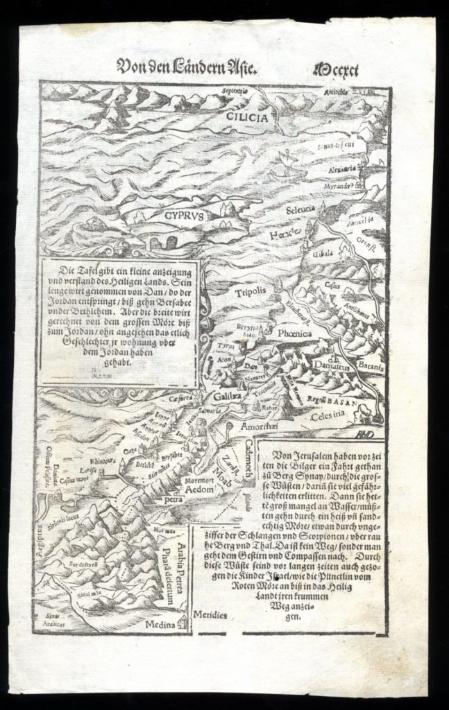
[1] pg. 166×260 mm. Map of the Mediterranean Sea, from South Turkey to the Delta Nile. Impressive woodcut. Including drawings of houses in Jerusalem, in the Galilee and more. Fish in the sea. Tiny ships. In the map two frames of text in German, and German text on the other side of page. One worm hole. Very fine condition.

Error: the field format must contains "%s" or "%1$s".

The price includes a buyer's commission

Auction 089
Item 35
Map of the Holy Land. Abraham Ortelius. Antwerp, 1579.

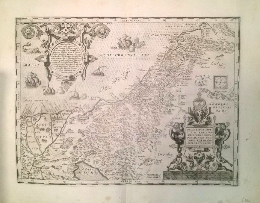
palestinae siue totius terrae promissionis nova descriptio auctore tilemanno stella sigenens Map of the Holy Land. ng. By Abraham Ortelius, following Tilemanno Stella. Antwerp, 1575. 56×90 cm. Latin. Copperplate engraving, tribal borders. Israelites’ path through the desert. “1579” printed above the cartouche in the upper left corner. First edition from the second of three plates. Quality paper, minimal marginal worming holes. Small tear in the fold. Very fine condition.

Error: the field format must contains "%s" or "%1$s".

The price includes a buyer's commission

Auction 089
Item 36
Map of the Holy Land. Stockholm, 1595. Heinrich Bunting

“Thet forloffuadhe Canaans Landz Bescriffuelse. Map of Israel before Arrival of the Israelites. By Heinrich Bunting. Stockholm, 1595. 29×20 cm. Old Swedish. Beautiful woodcut. Depicts the coastline from Sidon to Gaza, south of Sodom. Marks Biblical locations: Jericho, Givon, Mt. Tabor, and more. Jerusalem is noted by some of its other names: Shalem and Jebus. B&W. From the Swedish edition “Itinerarium Sacrae Scripturae Thetar Een Reesebook.” 20 cm x 29 cm. Very rare map. Not in Laor. Laor pp. 139 lists other editions Professional repair at left. Fine condition.

Error: the field format must contains "%s" or "%1$s".

The price includes a buyer's commission

Auction 089
Item 37
Map of Eretz Yisrael. Heinrich Bunting. Stockholm, 1595.

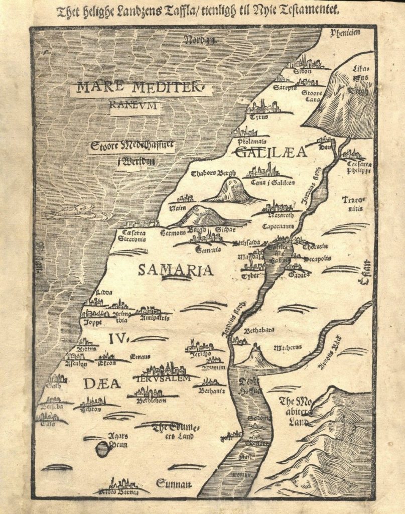
Thet Helighe Landzens Taffla/tienligh til anie testamentet. Map of Eretz Yisrael during Biblical times, divided into three regions: Galilee, Samaria and Judea. By Heinrich Bunting. Stockholm, 1595. 29×23 cm. Old Swedish. Nice woodcut, shoreline from Sidon through Gaza. The Dead Sea in the south, with the Jordan and Arnon Rivers emptying into it. Biblical locations marked: Jerusalem, Jericho, Efron, Mt. Tabor and more. From the Swedish edition: “….Itinerarium Sacrae Scripturae Thetar Een Reesebook”. Very rare map. Not listed by Laor. Professionally restored blemish to the left margin. Very fine condition.

Error: the field format must contains "%s" or "%1$s".

The price includes a buyer's commission

Auction 089
Item 38
Map of the Land of Israel with Tribal Divisions. Heinrich Bunting, 1595, Stockholm

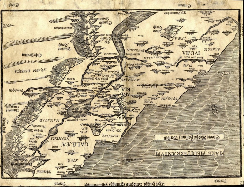
“Thet Helighe Landzens Egentligh.” The Land of Israel divided by the 12 tribes. Both banks of the Jordan River. Heinrich Bunting. Stockholm, 1595. 29×38 cm. Old Swedish. Nice woodcut depicting the coastline from Beirut to Gaza; the Mountains of the Gilead in the East; the mountains of Lebanon and the Hermon in the North; and the Dead Sea in the South. Black and white. Swedish explantoary text on the reverse. A number of light professional repairs. Fine condition. Not listed by Laor. Very rare.

Error: the field format must contains "%s" or "%1$s".

The price includes a buyer's commission

Auction 089
Item 39
Map with an Illustration of the Exodus from Israel. Israels Barnas Reefors thur Egypten. Heinrich Bunting. Stockholm, 1595.

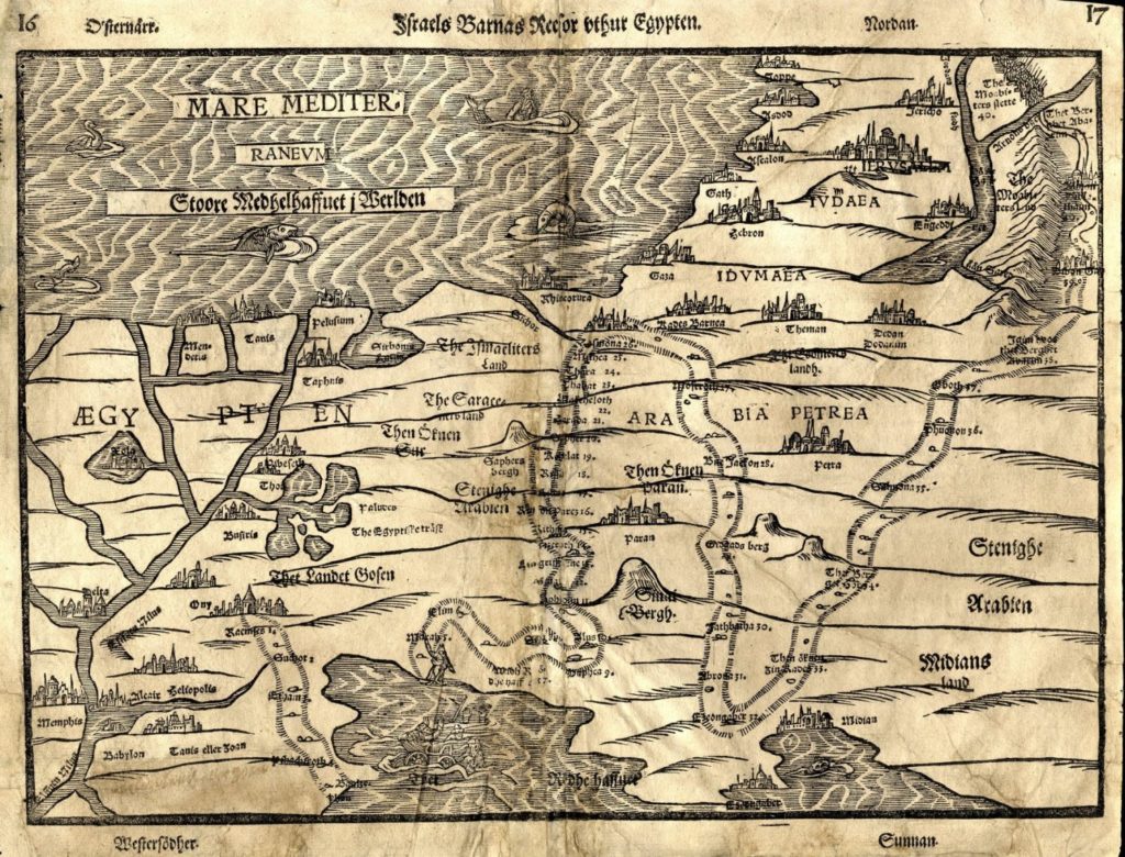
Israelites’ travels from Egypt. By Heinrich Bunting. Stockholm, 1595. 29×37 cm. Old Swedish. Nice woodcut, Israelite’s travels from Ramses through Jericho. Shoreline from Jaffa through the Nile Delta. Illustrations related to the exodus from Egypt, for instance: an Egyptian soldier drowning in the Yam Suf. Black and white. Explanatory text in Swedish on the reverse. Not listed by Laor. A number of light professional repairs. Fine condition.

Error: the field format must contains "%s" or "%1$s".

The price includes a buyer's commission

Auction 089
Item 40
Map of the Holy Land in its Twelve Tribal Divisions. Mercator Hondius. Amsterdam, 1619

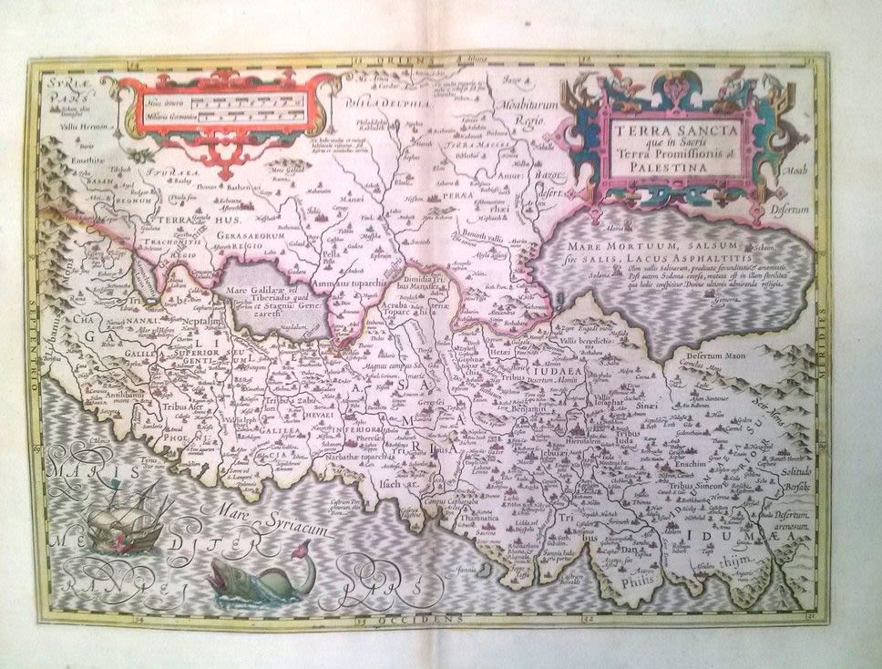
Terra Sancta quae in Sacris Terra Promissionis ol: Palestina. Map of the Holy Land divided amongst the twelve tribes. Amsterdam, 1619. 48×57 cm. Colored. Copperplate engraving. View from west to east. Shoreline from Beirut to Gaza .From Mercator, Gerrard. Atlas sive cosmographicae meditations. This map is an updated engraving of Ortelius’ map of 1584 that was designed by Schort, and based on Laicstain Mercator’s description. With an additional illustration of Jonah being thrown from the ship to the whale and an illustration of Sodom and Gomorrah burning in the Dead Sea. Small loss in the fold. Very fine condition. Laor, 494.

Error: the field format must contains "%s" or "%1$s".

The price includes a buyer's commission

Auction 089
Item 41
Map of Israel. KARA. [1949/1950]

Map of Israel, drawn by KARA. Colored. Published by Dr. Y. Shapiro, Tel-Aviv, printed in Kfar Monash, [1949-1950]. [1] large pg. 34.5×64 cm. ‘Year two to the State of Israel’ printed at the head of the page. Signed by the artist in Hebrew and Latin at top left hand side. One of the most impressive and colorful maps of that time period. Original fold marks. Very fine condition. Includes ten additional Hebrew maps from those years. Some decorative and colorful. All are in fine condition.

Error: the field format must contains "%s" or "%1$s".

The price includes a buyer's commission

Auction 089
Item 42
Map of Jerusalem. Hartmann Schedel. Incunabula. Nurnberg, 1493

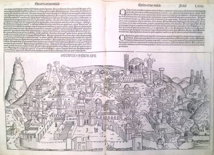
Desruccio Iherosolime. Panoramic map of Jerusalem during its destruction. By Hartmann Schedel. Nurnberg 1493. Incunabula. Folded leaf. 40×56 cm. Latin. View from east to west. Depicts the Holy Temple in flames. From: Liber cronicarum [The Nurnberg Chronicle], leaf LXIII (in the upper right corner). Woodcut. By Michael Wohlgemut and Wilhelm Pleydenwurff. One of the first original maps of Jerusalem still extant today. Latin text on the reverse along with anti-Semitic illustrations. Quality paper. Small holes in the fold. Very fine condition. Laor, 1125.

Error: the field format must contains "%s" or "%1$s".

The price includes a buyer's commission

Auction 089
Item 43
Picturesque Palestine. Charles Wilson. Four Volume Set + Supplemental Volume. London, 1884. Hundreds of Illustrations

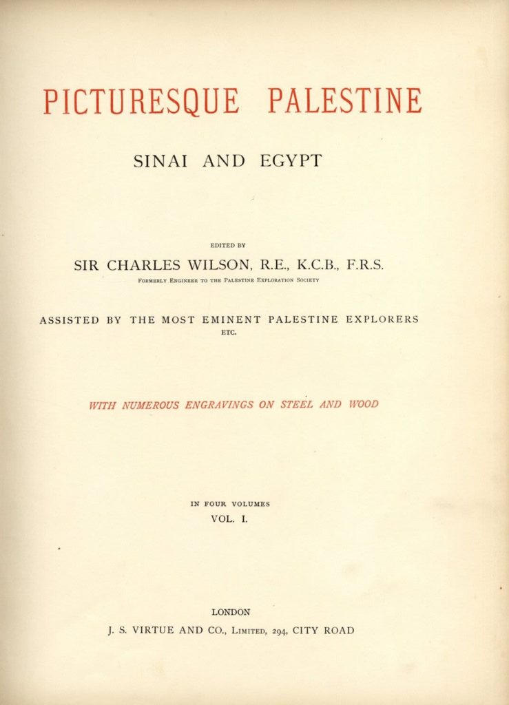
Picturesque Palestine, Sinai and Egypt arranged by Colonel Sir Charles Wilson. London, [1884]. Four volumes. 32 cm. Additional volume: Social Life in Egypt, a description of the country and its people. By Stanley Lane-Poole. London, 1884. Hundreds of illustrations, including large illustrations printed on special paper. The title page notes that this is a supplement to Picturesque Palestin. 32 cm. Printed on quality paper. Comprehensive guide and study of Palestine, written with the aid of experts in the field, includes scenery, customs, dress and commerce. Hundreds of illustrations, including tens of large illustrations printed on special paper. This is Colonel Sir Charles Wilson’s most significant work. The Wilson Arch located near the Western Wall is named for him. One of the fundamental works for the study of Jerusalem and Palestine in the 19th century. Original bindings with gold embossing. Gilt cut leaves. Minimal worming holes – primarily to the binding itself. Very fine condition.

Error: the field format must contains "%s" or "%1$s".

The price includes a buyer's commission

Auction 089
Item 44
Geography of the Land of Cana’an. Samuelis Bocharti [Leiden, 1692?]. Includes Maps

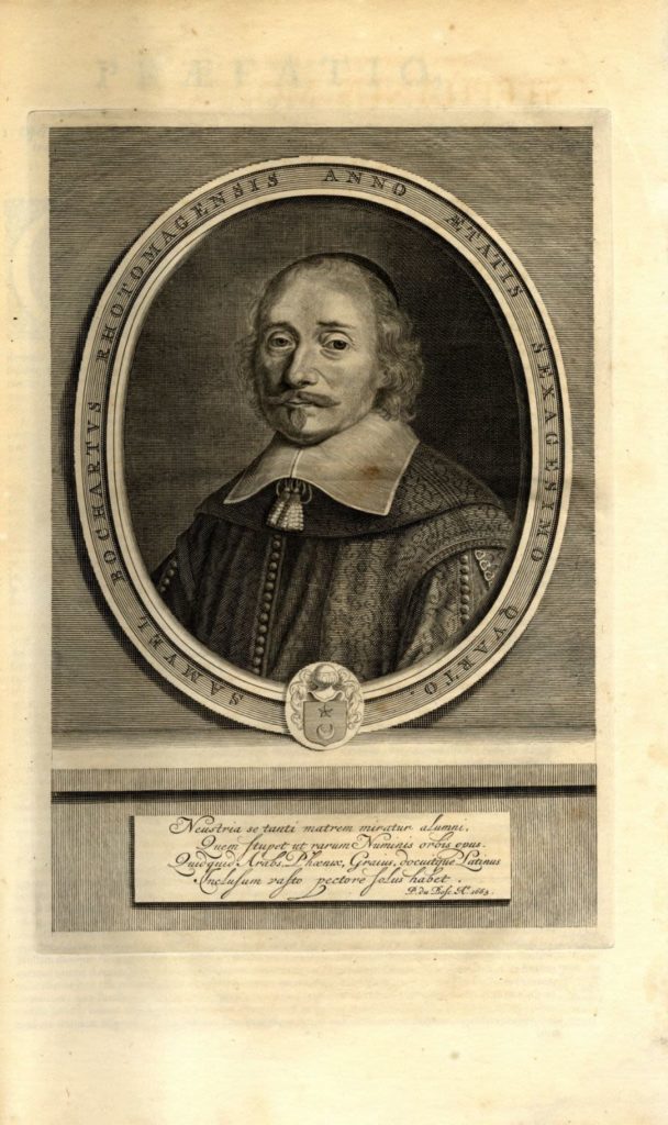
Samuelis Bocharti Geographia sacra, seu, Phaleg et Canaan. [Leiden, 1692?]. Geographic work on the land of Cana’an and other nations mentioned in Genesis. Latin. Includes 13 maps printed on special paper, including large folded maps. The maps of the various lands are partially written in Hebrew [!]. There are very few known maps of the Holy Land and the Middle East from such an early era in Hebrew. Missing the title page, but including all the maps. Portrait of the author at the beginning. Samuelis Bocharti (1599-1667) was an Orientalist and a French Protestant priest. Old parchment binding. Minimal aging stains. Very fine condition.

Error: the field format must contains "%s" or "%1$s".

The price includes a buyer's commission

Auction 089
Item 45
Beautiful Travelogues. London Prints. [3]. 1864-1870

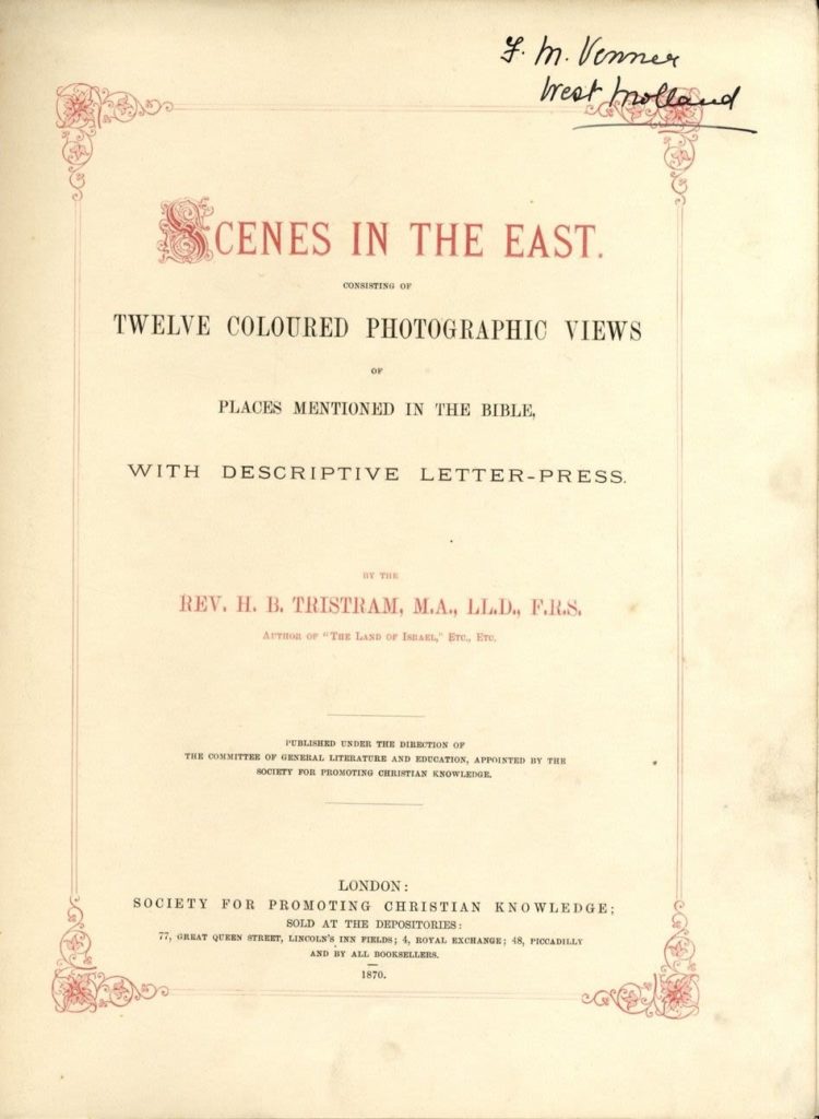
Three travelogues to the Holy Land with colored plates. London, 1864-1870. *Scenes in the East. First edition, London 1870. 49 pages. Includes 12 colored works of cities in the land and an eye-catching, impressive panoramic map of Jerusalem (28×53). (This map is missing from the copies in libraries). Gilt cut leaves and an illustrated, gilt binding. Fine condition. *Lakes and Rivers of the Bible. First edition, London 1864. 224 pages. Includes twelve colored illustrated plates of the water sources mentioned in the Bible, with protective parchment paper. The book features a geographic and musical description of the land. Gilt cut leaves and gilt binding. Very fine condition. *Jerusalem and its environs. Second edition. London, 1864. 224 pages. Includes 4 colored plates of Jerusalem (with protective parchment paper) that did not appear in the first edition. Geographic description of the land and its vegetation, along with a musical description with music notes for an Arabic wedding at the Dead Sea. Very fine condition. Gilt cut leaves and an illustrated, gilt binding. Inscription on the binding. Fine condition.

Error: the field format must contains "%s" or "%1$s".

The price includes a buyer's commission

Auction 101
Item 63
Incunabulum. A Map of Jerusalem. Hartmann Schedel, Nuremberg, 1493

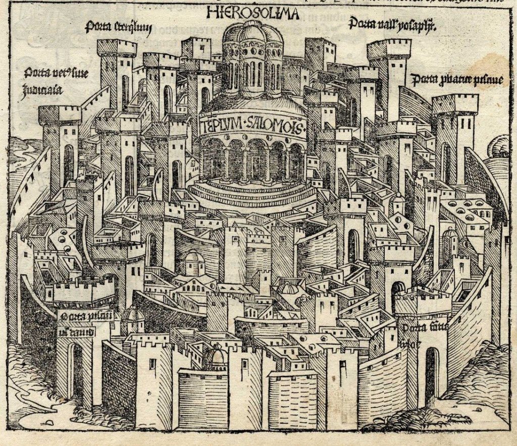
An imaginary map of the walled city of Jerusalem. The Temple surrounded by a round city as it was traditionally depcited in the Middle Ages. By Hartmann Schedel. Nuremberg, 1493. Incunabulum.
A beautiful wooden engraving. Black and white.
From Liber Chronicarum: Das Buch der Croniken und Geschichten [Nuremberg Chronicle], p. xvii, the German edition.
Printed only 40 years after the invention of the printing press and a year after the expulsion of Spanish Jewry and Columbus’s discovery of America. One of the earliest maps of Jerusalem currently known.
Leor, 1123. Rubin, Jerusalem in Maps and Views, page 60.
Engraving size: 23×19 cm. Leaf size: 40×28 cm.

Error: the field format must contains "%s" or "%1$s".

The price includes a buyer's commission

Auction 101
Item 64
A Collection [7] of Maps and Engravings on the Topic of Jerusalem, the Temple and the Land of Israel. 17-18th Century

* Campo Dege Israeliti. An engraving of the Tabernacle including the symbols of the tribes, the tribes’ camping places around the Tabernacle, and the census of each tribe. Size: 34×22 cm.
* Rama. A large engraving depicting the Rama. 1740. Size: 63×24 cm.
* Tabula Israelitarum in Deserto . A map of the Land of Israel including the Arabian Desert. Size: 46×35 cm.
* Mensvrae Quibus Veteres Locorum Intervalla Metiuntur. An engraving depicting ancient Jerusalem with the Temple Mount in its center, with two pleasant cartouche at the bottom. Size: 30×20 cm.
* Tribus Juda Verfa Orientem. A map of the area of Judea with two pleasant cartouche. Writing in Latin. Size: 39×30 cm.
* Syrie Ancienna. A map of the Land of Israel including Syria. 11×15 cm.
* Armenia, Syria, Mesopotamia. A map of the Land of Israel including the continent of Asia. Size: 19×15 cm.
Sizes and condition vary, fine overall condition.

Error: the field format must contains "%s" or "%1$s".

The price includes a buyer's commission

Auction 101
Item 65
Collection of [4] maps - engravngs. Hebrew letters. 18th-19th century

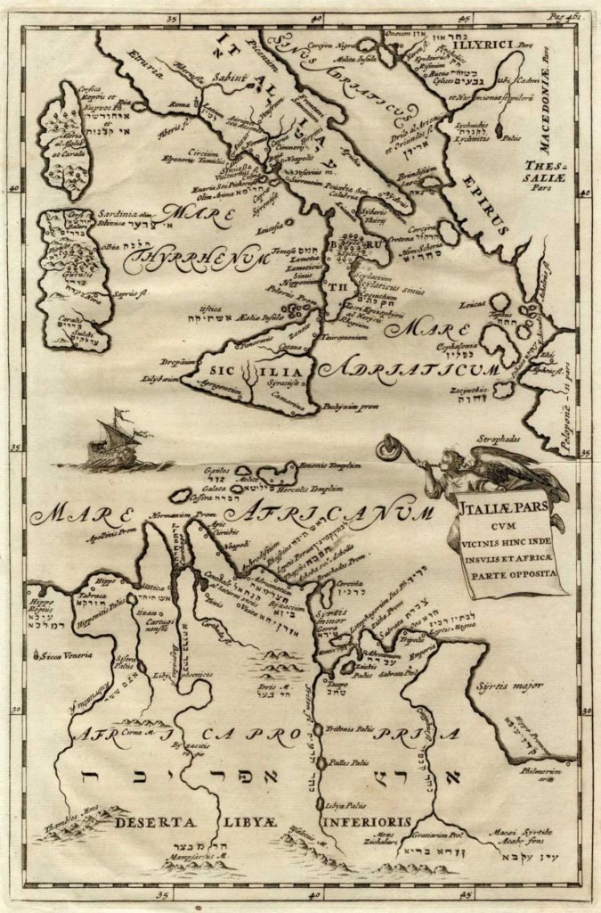
* Jtalliae Pars . Geographic map of sections of North Africa, the Mediterranean Sea and Italy, with Latin and Hebrew text [some of the locations are marked with their Biblical names such as: Mt. Ebal, Evra, Tifsach and others].
* Taprobana Insvla Des Criptio Ptol . India. Hebrew letters at center of the map.
* The Black Sea. Map integrates Latin with Aramaic words in Hebrew letters, such as שכן דארעא, חלק טהיר, פליא נחש and more.
* Patica Partis . The Iberian Peninsula, various texts in Latin and parallel Hebrew: Tarshish, Shual etc.
Average size: 29×20 cm.
Varying conditions, overall fine condition.

Error: the field format must contains "%s" or "%1$s".

The price includes a buyer's commission

Auction 101
Item 66
A Collection [4] of Maps - Engravings of the Land of Israel. 19th Century

* Map of Canaan or the Holy Land . Published by Baldwin & Gradock, London 1855. Size: 18×15 cm.
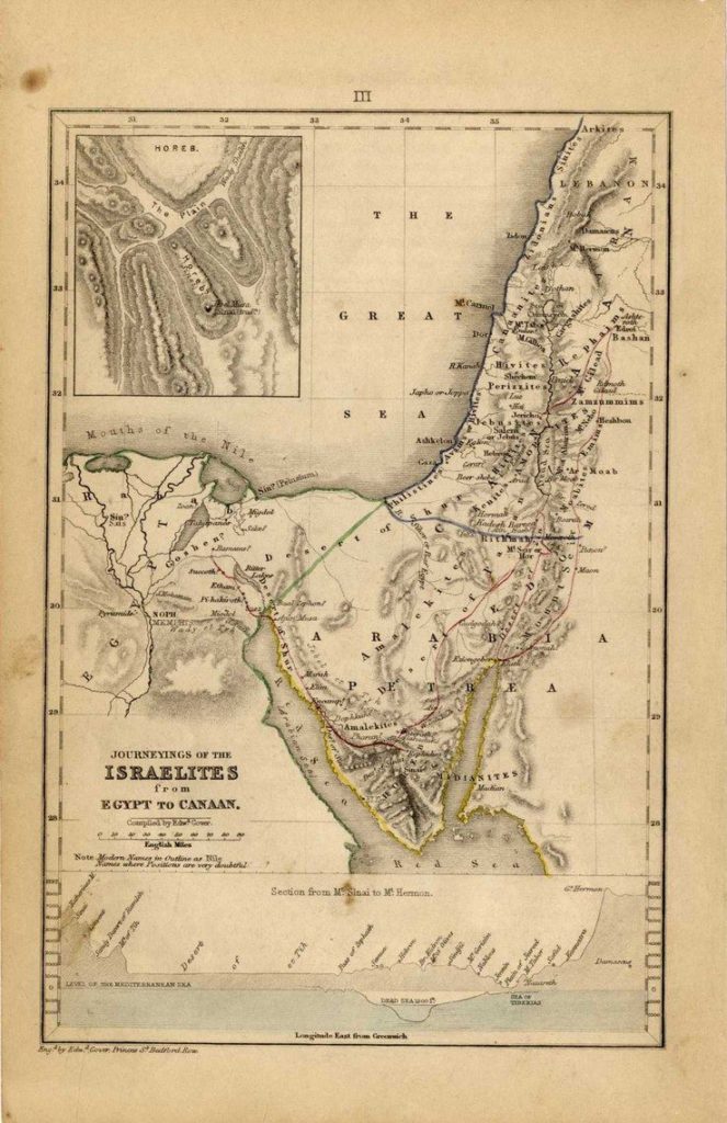
* Journeyings of the Israelites from Egypt to Canaan. London 1831. Size: 23×15 cm.
* Palestine. A large map of the Land of Israel. On the right are two small maps according to the kingdoms of David and Shlomo. On the right is a pleasant cartouche in the form of a tent, with the word Israel written in Hebrew and English. Size: 30×22 cm. Early 19th century.
* Map of Palestine published by Gall & Inglis, Edinburgh 1859. Size: 56×47 cm. Folding mark in the center of the map.
All of the maps are in fine condition.

Error: the field format must contains "%s" or "%1$s".

The price includes a buyer's commission

Auction 101
Item 67
A Collection [5] of Maps - Engravings. Egypt and Arabia. 17-18th Century

* The Desert Arabia. A map of the Arabian Desert, including Egypt’s sea, early 17th century. 26×35 cm.
* Arabia Petraea et Deferta , Arabian Desert, 17-18th century. 24×36 cm.
* The Desert Arabia. An ancient engraving, painted by hand from the period of printing, of the Arabian Desert adjacent, as it was in the 18th century. A 26×36 cm engraving.
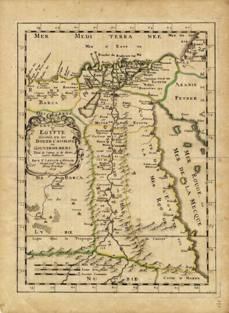
* Egypte. Two similar geographical maps, one painted by hand from the time of printing, which show northern and southern Egypt. 18th century. 20×28 cm.
Conditions vary, fine overall condition.

Error: the field format must contains "%s" or "%1$s".

The price includes a buyer's commission

Auction 101
Item 68
Four Maps - Engravings. The Arabian Peninsula. 17th Century

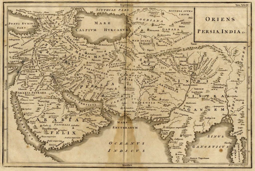
Four ancient maps – engravings of the Arabian Peninsula. Three at the average size of 11×15 cm. One [Oriens Persia, India], is sized 31×21 cm.
Stains, fine condition.

Error: the field format must contains "%s" or "%1$s".

The price includes a buyer's commission

התחל להקליד ע"מ לקבל תוצאות רלוונטיות

Question about item

Collection of [9] antique, colored maps of Palestine. 18th-19th century

Start typing p to get relevant results

Auction house conditions

A GUIDE TO THE PARTICIPANTS IN THE EXHIBITION AND PUBLIC AUCTION REGULATUON AND PROCEDURES
 Winner’s Auction LTD (the company) – is hereby holding an exhibition in Judaica, to enable the public to examine these
important items, with the possibility of purchasing them at an auction sale to be held at the conclusion of the exhibition. For the convenience
of the public, we have published a detailed catalogue with photographs and descriptions for each item. Catalouge description are based on
the opinions of our experts. However, the sole responsibility of the buyer to inspect each lot. Please regard the catalogue as your personal
guide to the exhibition and auction. Our staff will be at your assistance throughout the exhibition and auction.
Administration of the auction and conditions of Auction:
The auction itself will be directed by an experienced auctioneer according to the standards and regulations of auction houses. We request
visitors and participants to familiarize themselves with the regulations and current conditions. We recommend that people unfamiliar with
these regulations ask our staff at the exhibition for the information they deem necessary.
* Participation in the public auction and receipt of a “participant’s number” are tantamount to the confirming and agreeing that the
recipient of the number is familiar with the regulations, procedures, and conditions of our exhibitions and public sales. Any problems
arising during the auction sale or afterwards as a result of a purchase will be resolved by the purchaser and the management of the company
in according with accepted practice.
* Since the company is merely the organizer and administrator of the exhibition and auction, and is not the owner of the items themselves,
it is hereby agreed and stipulated that in no case will the Company be responsible to the purchasers after the transfer of the payment to the
seller- owners. Thus, in case the payment received from a purchaser has already been transferred to the owner, and even if the complaint
or claim made by the purchaser is justified, and we make every effort to have his money retuned to him by the owner, we shall be under
no obligations to do so, and shall not engage in any legal proceedings after it has been handed over to the owner, though we shall agree
to provide the purchaser with suitable documentations on our part to enable him to engage in such legal proceedings against the owner.
* Upon receipt of the “participant’s number”, in person or via telephone, the potential buyer agrees and obligates himself not to prosecute
us or place a lawsuit against us in the event of damage caused or error in the catalogue description. Any complaints or claim after transfer
of the money to the seller, are only valid against the seller himself.
Prices and Estimates:
Participations in the auction is expressed: (a) by the personal presence of the purchaser in the hall; (b) by the presence of his representative;
(c) by means of written or telephoned bids empowering the management of the company to purchase various items for the person ordering
them (d) Via the Internet.
* The presence of the purchaser’s representative obliges him to make good his purchases, with whatever this entails. The company shall
not agree to obligate his sender or to free the representative of any obligation, even though the representative may fill his sender’s name
explicitly in our forms.
* If we receive a telephone or written order for a certain item, we shall strive to act in the interest of the person giving the order, just as if
he himself was in the hall. We, however, are under no obligation to obtain the item for him.
* We are under no obligation to accept any bid, including the highest bid, even though the purchaser or his representative is personally
present in the hall and participating in the auction.
* The auction itself is administered by announcing numbers in US$, though the actual payment may be made in either Shekalim in
accordance with the average rate of exchange which will be announced at the auction hall or at the day of the payment (The highest) or in USD.
* A 24% commission charge is added to all payment made by purchasers up to $500,000. 20% is added up to $501,000. A Vat ia added only on this comission charges. This percentage is an integral part of the bid accepted by the auctioneer during
the auction, and all obligations, etc, apply also to this percentage
* A foreign resident will be exempt from VAT only if the item purchased is shipped outside of the country by the company without its
guarantee and subject to receipt of an export entry from the custom authorities. The purchaser will cover all related expenses.
* Bank and personal checks are accepted tentatively, until they are honored by the bank.
* Payment by cash, checks or transfers within the country will be accepted without further charge. Foreign checks, credit cards (from
Israel) will be charged an additional 1.5%. bank transfers from foreign countries will be charged an additional 1.5% min. $30. Credit card
payments from foreign countries will be charged an additional 3%.
* Each item is accompanied by an estimate value made by our experts. There is no guarantee that the item will not be sold for a lower
estimate nor that the actual price of the item will not be much higher than the highest estimate value. This paragraph does not detract from
our consistent defense of the minimum price determined by the owner of the item.
Additional information and conditions:
* The purchaser or his representative will claim the purchased item as soon as possible. We request that he appear within seven days to
make the payment and collect the acquisition: under no circumstances is this to take place after 14 days from actual date of auction. After 14 days storage charges may be charged of $5.00 per lot per day. The purchaser himself is solely responsible for the dispatch of items to his home, in any way that he deems fit. The purchaser is responsible for the costs involved in such dispatch. Optional shipping insurance is available.
* The purchased item will not leave the company’s premises until payment is made.
* If payment is not received within 14 days of the auction, Winners reserves the right to cancel the sale unilaterally, without foregoing
their claim for commission.
* ATTENTION OWNERS: The company is not responsible for the actual carrying- out of payments undertaken by the purchasers during
the auction. In the event that obligations by the purchaser are not honored, we shall support the former owner of the item is taking steps
to obtain the payment owing him, but we shall not engage in legal procedures against purchasers. We shall proceed in all ways we find
suitable, but we are under no obligations to do so.
* Purchasers and sellers agree to be considered legal parties in every way in case we exercise the rights we are hereby granted to engage in
legal proceedings, or any other accepted steps against a party who does not honor its obligations.
* The Hebrew text of the catalogue is the correct version, and overrides any addition, omission or change in the English translation